Skip to main content
Cherrapunji, the capital of the rain
Cherrapunji
The city of rains, where there is no rain and the rain on the other side, people's eyes get stuck in waiting for it. In the waiting of the monsoon, Delhiites are forced to sweat on the other hand. But if it is rain and Cherapatuji's name does not get it, it can not be so. Fortunately for India, Cherrapunji is one of the most rain-fed areas in the world. The
famous Cherrapunji, known as the capital of rain, is located at an
altitude of about 1300 meters above sea level, which is 60 kilometers
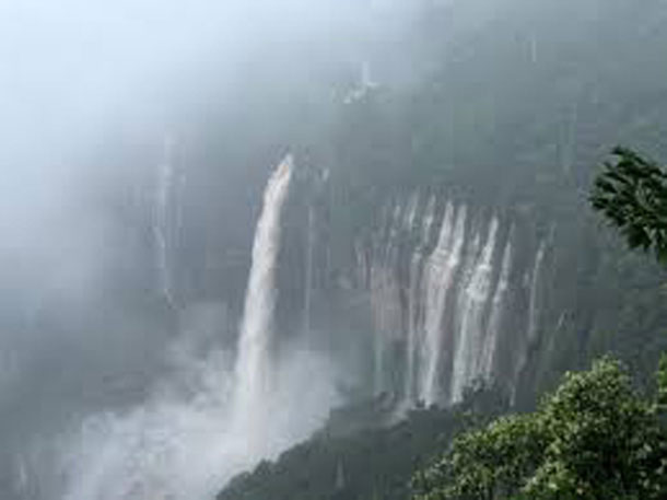
from Shillong, the capital of Meghalaya. Cherrapunji is also known as Sohra. The average rainfall here is 10,000 millimeters. In the rainy season, tourists come from far and wide. The hills of Cherrapunji, adorned with greenery, often drag people towards themselves. When it rains, Basant is on his face. Feet of falling water fountains from the height, viewing the clouds similar to the Kuhas has its own experience. Basant is very much waiting for the local residents here. The people of Khasi tribe in Cherrapunji welcome the monsoon in a different way. Folk songs and folk dances are organized to woo the clouds, which is a tourist attraction. In Meghalaya, the monsoon Ram has also recorded more rain than in recent times. But
it is ironic that the people of Cherrapunji, who got the reputation of
being the most rained, have to face the huge water crisis for a few
months every year. Here the drought starts showing its effect from November. At such times the people here have to depend on the water supply of public health engineering.Cherrapunji
(About this sound second pronunciation, with the historical name Sohra
being more commonly used, and can also be spelled Cherrapunjee or
Cherrapunji) is a subdivisional town in the East Khasi Hills district of
Indian state of Meghalaya. It is the traditional capital of a nongkhlaw hima (Khasi tribal
chieftainship constituting a petty state), both known as Sohra or
Churra.Cherrapunji is credited as the wettest place on Earth, but nearby Mawsynram currently holds that distinction. Cherrapunji
still holds the all-time record for most of the calendar month and in a
year, however: it received 9,300 millimeters (370 in; 30.5 ft) in July
1861 and 26,461 millimeters (1,041.8 in; 86.814 ft) between 1 August 1860 and 31 July 1861HistoryThe original name for this town was Sohra (soh-ra), which was named "Churra" by the British. This name eventually evolved into the current name, Cherrapunji,
meaning 'land of oranges', which was used first by tourists from other
parts of India.1947-Khasi states.pngDespite
the abundant rainfall, Cherrapunji faces an acute water shortage and
the residents often have trek very long distances to obtainable water.
Irization is also hampered due to excessive rain washing of the topsoil
as a result of human encroachment in the forests. The Meghalaya state government has renamed the Cherrapunji to its original name, "Sohra". There is a monument to David Scott (British Administrator in NE India, 1802-31) in the Cherrapunji Cemetery.The history of the Khasi people - native inhabitants of Cherrapunji - may be traced from the early part of the 16th century. Between
the 16th and 18th centuries, these people were ruled by their tribal
'Syyems (Rajas or Chiefs) of Khyriem' in the Khasi Hills The Khasis Hills came under British authority in 1883 with the submission of the important Syiems, Tirot Sing.


Comments